 FAO Map Catalog
USGS/EROS Data Center (Hydro1k)
Type of resources
Available actions
Topics
Keywords
Contact for the resource
Provided by
Years
Representation types
Update frequencies
status
Scale
-

H1k_FLOW: River "flow accumulation" network from the HYDRO1k for Africa, reprojected to decimal degrees from Lambert Azimuthal Equal Area base, the only "networked" AWRD River layer. HYDRO1k is the Global Hydrological 1 kilometre database of hydrologically filled DEMs, "river" flow, and watershed networks based on the GTopo30. The H1K_FLOW shapefile data layer is comprised of 15478 derivative raster watershed and flow network features derived based on 4 000 cell data originally from HYDRO1k. The layer provides nominal analytical/mapping at 1:2 000 000. Data processing is complete globally, this is an African subset. HYDRO1k - HYDRO1k - Global Hydrological 1 kilometre database of hydrologically filled DEMs; AWRD - FAO-FIMA?s African Water Resources Database & Tools Interface; DEM - Digital Elevation Model.
-

H1k_WS: 6-level watershed model based on the HYDRO1k, reprojected, verified, and downstream encoded version of the 6th level Pfafstetter encoded H1k watersheds. The H1K_LEV6 shapefile data layer is the comprised of 7133 derivative raster watershed and flow network features derived based on 4 000 cell data originally from HYDRO1k. The layer provides nominal analytical/mapping at 1:2 000 000. Data processing is complete globally, this is an African subset. Acronyms and Abbreviations: HYDRO1k - Global Hydrological 1 kilometre database of hydrologically filled DEMs, "river" flow, and watershed networks based on the GTopo30; GTopo30 - GT30/GTopo30 - Global Topographic 30 arc second DEM database, nominal 1km postings.
-
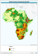
An hydrologically filled version of the GTopo30 DEM employing a Afro-centric Lambert Azimuthal Equal Area Projection. The H1K_LAEA grid data layer is comprised of 9194x8736 derivative raster hydrologically filled dem features derived based on 1 kilometer data originally from HYDRO1k. Acronyms and Abbreviations: GT30/GTopo30 - Global Topographic 30 arc second DEM database, nominal 1km postings; DEM - Digital Elevation Model.